

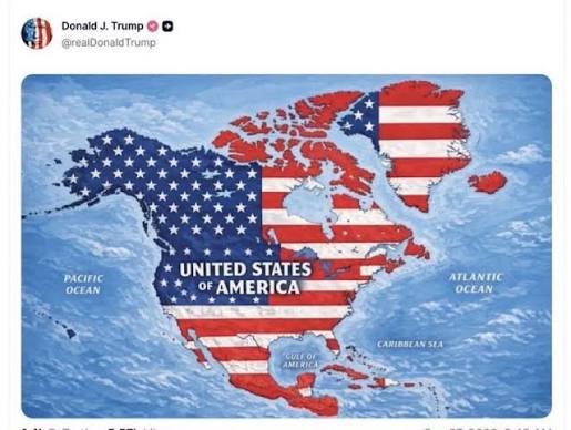
US President Donald Trump has shared a map depicting the American flag across a large part of North America, as well as Iceland and several Caribbean islands, reviving attention around his previous remarks about expanding US territorial control beyond the country’s borders.
Trump posted the map on Truth Social on Monday morning. The image showed the American flag superimposed over the United States, Canada, Mexico, parts of Central America, Greenland and Iceland, along with Caribbean nations and territories including Cuba and Jamaica.
Trump has previously expressed interest in acquiring Canada and Greenland and taking control of the Panama Canal. However, the appearance of Mexico and several Caribbean islands in the latest map represents a broader depiction of territories associated with his ambitions.
The post comes at a time of heightened tensions between Washington and Ottawa over trade. The United States and Canada have imposed tariffs on each other’s goods over the past month.
Amid the dispute with Canada, Trump also signed an executive order seeking to rename Lake Ontario, which shares its name with the Canadian province, as “Lake America.”
Trump’s latest post followed another map-related image he shared on Sunday involving the US state of New Mexico.
The president posted a map of New Mexico labelled “New America” after an online hoax falsely claimed that he had signed an executive order changing the state’s name.
The image showed a large “X” placed over the word “Mexico” in the state’s name, with “America” written underneath it.
The White House’s official account also shared the image on X.
The latest map has drawn attention because it portrays a significantly wider area under the American flag than the territories Trump has previously discussed in relation to US expansion.